


Rando n°4 Les Rousses

dudu79
User
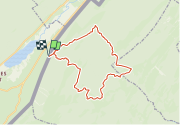

Length
15.8 km

Max alt
1506 m

Uphill gradient
688 m
Km-Effort
25 km

Min alt
1122 m

Downhill gradient
687 m
Boucle
Yes
Creation date :
2024-06-20 07:09:13.367
Updated on :
2024-06-20 07:09:25.165
5h40
Difficulty : Very difficult

FREE GPS app for hiking
 SityTrail
IGN / Geographical institutes
SityTrail Plus
The world is yours!
About
Trail Walking of 15.8 km to be discovered at Bourgogne-Franche-Comté, Jura, Les Rousses. This trail is proposed by dudu79.
Positioning
Country:
France
Region :
Bourgogne-Franche-Comté
Department/Province :
Jura
Municipality :
Les Rousses
Location:
Unknown
Start:(Dec)
Start:(UTM)
278180 ; 5154047 (32T) N.
Comments